


United Kingdom Map
Contest Access
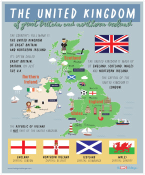
A3 classroom poster for A1: the four nations of the UK with their capitals, symbols and landmarks, plus the difference between the UK, Great Britain and the British Isles.
Your Classroom Poster
A ready-to-use visual aid for your classroom. Download this high-definition poster to print.
To download this material, you must be logged in with a teacher account registered for The Big Challenge contest.
Pedagogical Guide
Objective & content
This poster presents the United Kingdom as four nations, each with a capital, a symbol and a landmark: for example Edinburgh, the thistle and Edinburgh Castle for Scotland. By the end, A1 students can name the four nations and their capitals and explain how the UK, Great Britain and the British Isles differ.
Pedagogical guide
The core idea is one country made of four nations. Present the four cards in parallel, since each lists a capital, a symbol and a landmark in the same order, before you open the Know the difference panel. That panel clears up a common muddle: Great Britain leaves out Northern Ireland, and the British Isles include the Republic of Ireland, a separate country. The poster is made of text and flag emoji, not a drawn map.
Suggested procedure
- (5 min) Read the legend aloud: The UK = England + Scotland + Wales + Northern Ireland.
- (10 min) Go nation by nation; students repeat The capital of Wales is Cardiff.
- (5 min) Draw nested circles on the board for Great Britain, the UK and the British Isles and read the panel against them.
- (5 min) Quiz: name a nation and students give its capital, symbol or landmark.
Adaptations
[S] Teach only the four capitals and the Union Jack in the first pass.
[A] Students find one more fact about a landmark, such as the Giant's Causeway, and present it.
Materials & prerequisites
Print at A3 portrait. Students need simple present sentences with is. French hints are printed on the poster; there are no exercises and no key.